Summary of Display GPS Co-ordinates on LCD using pic microcontroller
This article details the construction of a mobile real-time GPS tracker integrated with Google Maps. The system uses a microcontroller to process GPS data, transmitting it via GPRS to a server where it is stored in a MySQL database. A web interface retrieves this data every second and displays the live location on a map using JavaScript and the Google Maps API. The project utilizes open-source hardware and software, costing approximately $200, and serves as an educational weekend build for integrating various electronic and web technologies.
Parts used in the Mobile Real Time GPS Tracker:
- Arduino Duemilanove or Arduino Uno microcontroller
- SpreadTrum SM5100B GSM/GPRS Module
- USGlobalSat EM-406A GPS Module
- GPS Interface Board
- Arduino Stackable Headers
- GPS Shield
- GSM Shield
- mySQL Database
- Zope Web Application Server
- Google Maps API
This project describes how you can build a mobile real time GPS tracker with integrated Google Maps. I began this project mainly to see if I can integrate all the different pieces of hardware and software to make a workable solution, and it took some time, but finally when everything was said and done, it looked pretty cool. I tore down everything and rebuilt it from scratch, making detailed notes and documenting the process.
When I started building this, I didn’t have any particular application in mind, but now that I have built it, I can see myself using it different applications, particularly if I can get to lower the cost. Even if you didn’t have any application in mind, it would be a fun weekend project, you never know, you might find the knowledge gathered during the process useful one day in some form or other.
How it works?
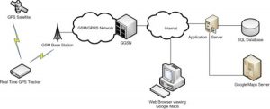
In a nutshell, this is how the GPS Tracker works. The GPS chip outputs the positioning information which is transferred over a GPRS link to the mobile operator’s GGSN (Gateway GPRS Support Node) and then to a remote server over a TCP connection. The TCP server stores the incoming positional data in a mySQL database. When a user clicks on the tracking page, Zope, which is an open source web application server, serves up an HTML page with an embedded javascript code. The javascript would run in the user’s browser and has instructions to retrieve the positional information from the mySQL database every second. It then integrates this information into Google Maps through Google Maps API which displays the position on a map. Since the positional information is retrieved every second and the maps updated at the same frequency, a real time GPS tracking effect is achieved.
How much does it cost?
The costs are all associated with the hardware components. There is no software costs involved, since everything is open source. The code is licensed under Creative Commons, so you’re free to use the code in this project in whatever applications you wish.
The total estimated cost is around $200. All the components can be purchased from Sparkfun.
HARDWARE
The hardware consists of three main components.
Microcontroller
The micro-controller is the central controller for the whole unit. I chose the Arduino Duemilanove, which is an open source electronics prototyping board based on the Atmel ATMega328 8 bit micro-controller running at 16 Mhz. This newer version of this board can be purchased from here and costs around $30. It’s called Arduino Uno and works just as well.
GSM/GPRS Module
The GSM/GPRS Module is based on SpreadTrum’s SM5100B. The SM5100B is a miniature, quad-band GSM 850/EGSM 900/DCS 1800/PCS 1900 module. This module features two UARTS, an SPI interface, and two 10-bit ADC’s. This board can be purchased from here and costs about $100.
GPS Module
The GPS Module is USGlobalSat EM-406A which is based on the spectacular SiRF Star III chipset. It outputs positioning and timing date in NMEA 0183 and SiRF binary protocol and has a positioning accuracy of 10 meters without and 5 meters with WAAS. You have to buy a separate interface board and the GPS unit and connect the two. The interface board can be purchased from here and costs $16. The GPS receiver can be purchased from here and costs $ This unit can be purchased from here and costs $60.
Step 2:
HARDWARE ASSEMBLY
If you are using the hardware components I used, the assembly is pretty staightforward. Solder the Arduino stackable headers (can be bought from here) on the GPS shield and the GSM shield. Connect the GPS module to the GPS shield and stack it on top of the GSM board. Stack the two boards on top of the Arduino board.
Source: Display GPS Co-ordinates on LCD using pic microcontroller
- How does the GPS tracker work?
The GPS chip sends positioning data over a GPRS link to a remote server where it is stored in a mySQL database, then retrieved by a web page using JavaScript to display on Google Maps. - What is the estimated cost of building this project?
The total estimated cost is around $200, covering all hardware components with no software costs involved. - Which microcontroller was chosen for the central controller?
The Arduino Duemilanove based on the Atmel ATMega328 8 bit micro-controller running at 16 Mhz was chosen. - Does the project require any paid software licenses?
No, there are no software costs because everything used is open source and licensed under Creative Commons. - What chipset powers the GPS module used in this build?
The GPS module is based on the SiRF Star III chipset. - How frequently is the map updated with new position data?
The positional information is retrieved from the database every second, updating the map at the same frequency. - Where can the hardware components for this project be purchased?
All components mentioned in the article can be purchased from Sparkfun. - What protocol does the GPS module output positioning data in?
The module outputs positioning and timing data in NMEA 0183 and SiRF binary protocol.